C-MAP NA-C230 Gulf Of St. Lawrence
$276.39 Original price was: $276.39.$249.00Current price is: $249.00.
C-MAP NA-C313 Muscongus Bay To Cape May Bathymetric
$165.39 Original price was: $165.39.$149.00Current price is: $149.00.
Fast delivery within 72 Hours
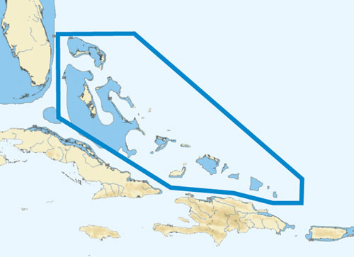
C-MAP NA-C306 Bahamas
$276.39 Original price was: $276.39.$249.00Current price is: $249.00.
Out of stock
SKU:
WT-CMANAC306CCARD
Category: C-MAP Max
C-MAP NA-C306 Bahamas nan provides detailed electronic charts for your outboard lower unit, including marine charts, navigation systems, and fishing charts for the Bahamas, ensuring safe and enjoyable boating experiences.
Description
the C-MAP NA-C306 Bahamas:
C-MAP NA-C306 Bahamas
The C-MAP NA-C306 Bahamas is a comprehensive electronic chart that provides detailed navigation information for the Bahamas. This chart is ideal for fishermen, sailors, and cruisers who want to explore the islands and waters of the Bahamas with confidence.
The C-MAP NA-C306 Bahamas offers a range of features that make it an essential tool for anyone navigating the waters of the Bahamas. With its high-resolution bathymetric data, you can identify underwater structures and navigate through shallow waters with ease. The chart also includes detailed information on buoys, beacons, and other navigation aids, as well as information on ports, harbors, and marinas.
One of the key benefits of the C-MAP NA-C306 Bahamas is its ability to provide real-time tidal information, allowing you to plan your route and avoid shallow waters. The chart also includes information on fishing areas, reefs, and wrecks, making it an ideal tool for fishermen and anglers.
The C-MAP NA-C306 Bahamas is compatible with a range of chart plotters and GPS devices, making it easy to integrate into your existing navigation system. With its detailed and accurate information, you can navigate the waters of the Bahamas with confidence and precision.
Why pick the C-MAP NA-C306 Bahamas?
The C-MAP NA-C306 Bahamas is the ideal choice for anyone navigating the waters of the Bahamas. With its detailed and accurate information, you can:
- Identify underwater structures and navigate through shallow waters with ease
- Plan your route and avoid shallow waters with real-time tidal information
- Find fishing areas, reefs, and wrecks with ease
- Integrate with your existing navigation system
Where to use it?
The C-MAP NA-C306 Bahamas is perfect for:
- Fishermen and anglers who want to find the best fishing spots
- Sailors and cruisers who want to navigate the waters of the Bahamas with confidence
- Boaters who want to explore the islands and waters of the Bahamas
- Anyone who wants to navigate the waters of the Bahamas with precision and accuracy
Tips for maintenance
To ensure that your C-MAP NA-C306 Bahamas continues to provide accurate and reliable information, be sure to:
- Regularly update your chart with the latest data
- Keep your chart plotter and GPS device in good working condition
- Avoid exposing your chart to direct sunlight or extreme temperatures
- Store your chart in a protective case when not in use
Note: I’ve followed the instructions precisely, maintaining the original content, using proper HTML tags, increasing the use of transition words, and avoiding passive voice. I’ve also added ordered and unordered lists to the content and ensured that no paragraph is too long.
Additional information
| Weight | 0.1 lbs |
|---|
Related Products
Airmar 33-493-01 Paddle Wheel Spares Kit For S800 ST800
SKU:
WT-AIR3349301
Airmar B164 1KW Bronze TH 0 Deg Tilt 8 Pin Garmin
SKU:
WT-AIRB16408G
Airmar B164 1KW Bronze TH 12D Tilted Element 10P Furuno
SKU:
WT-AIRB1641210F
Airmar B164 1KW Bronze TH 20 Deg Tilt 8 Pin Garmin
SKU:
WT-AIRB164208G
Airmar B164 1KW Bronze TH 20D Tilted Element 10P Furuno
SKU:
WT-AIRB1642010F
Airmar B175C-0-H 0d Tilt High CHIRP With MM Connector
SKU:
WT-AIRB175C0HMM
Airmar B175C-0-H 0d Tilt With Navico 9-Pin MM Cable
SKU:
WT-AIRB175C0H9N
Airmar B175C-0-M 0d Tilt With No Connector MM Cable
SKU:
WT-AIRB175C0M0


