C-MAP NA-C502 Western Caribbean Sea
$276.39 Original price was: $276.39.$249.00Current price is: $249.00.
C-MAP NA-C702 Nanoose To Victoria To Cape Scott
$276.39 Original price was: $276.39.$249.00Current price is: $249.00.
Fast delivery within 72 Hours
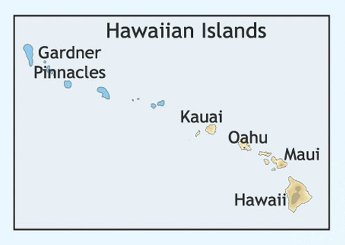
C-MAP NA-C603 Hawaiian Islands And Vicinity
$276.39 Original price was: $276.39.$249.00Current price is: $249.00.
Out of stock
SKU:
WT-CMANAC603CCARD
Category: C-MAP Max
“C-MAP NA-C603 Hawaiian Islands nan offers precise navigation for your outboard lower unit. Get accurate charts and maps for a safe and enjoyable boating experience in Hawaiian waters and vicinity.”
Description
C-MAP NA-C603 Hawaiian Islands And Vicinity
The C-MAP NA-C603 Hawaiian Islands And Vicinity is a comprehensive electronic chart featuring the Hawaiian Islands and surrounding waters. This chart provides detailed coverage of the islands of Oahu, Maui, Hawaii, Kauai, and Lanai, as well as the Northwestern Hawaiian Islands. With advanced chart plotting capabilities and a wealth of valuable information, the C-MAP NA-C603 Hawaiian Islands And Vicinity is an essential tool for mariners, fishermen, and outdoor enthusiasts alike.
As a mariner, you know how important it is to have accurate and reliable chart data. The C-MAP NA-C603 Hawaiian Islands And Vicinity provides you with the confidence to navigate the waters of Hawaii with precision and safety. With its detailed harbor charts, marina plans, and fishing charts, you’ll be able to explore the islands’ many hidden coves and secret spots like a local.
The C-MAP NA-C603 Hawaiian Islands And Vicinity is also an invaluable resource for fishermen. With its detailed fishing charts and information on fishing grounds, you’ll be able to find the best spots to catch your favorite species. And with its advanced chart plotting capabilities, you’ll be able to track your progress and plan your next move with ease.
Why pick the C-MAP NA-C603 Hawaiian Islands And Vicinity:
- Accurate and reliable chart data for safe and precise navigation
- Comprehensive coverage of the Hawaiian Islands and surrounding waters
- Detailed harbor charts, marina plans, and fishing charts for exploring hidden coves and secret spots
- Advanced chart plotting capabilities for tracking progress and planning your next move
Where to use it:
The C-MAP NA-C603 Hawaiian Islands And Vicinity is perfect for mariners, fishermen, and outdoor enthusiasts who want to explore the beautiful waters of Hawaii. Whether you’re sailing, fishing, or simply cruising around the islands, this chart provides the detailed information you need to navigate with confidence.
Tips for maintenance:
To ensure your C-MAP NA-C603 Hawaiian Islands And Vicinity chart remains accurate and reliable, be sure to:
- Regularly update your chart data to ensure you have the latest information
- Store your chart in a protective case to prevent damage
- Use a high-quality chart plotter to ensure accurate tracking and navigation
- Frequently check your chart for any signs of wear or damage
By following these simple tips, you’ll be able to enjoy the C-MAP NA-C603 Hawaiian Islands And Vicinity for years to come. With its comprehensive coverage, advanced chart plotting capabilities, and detailed information, this chart is an essential tool for anyone who spends time on the water in Hawaii.
The C-MAP NA-C603 Hawaiian Islands And Vicinity is the perfect choice for mariners, fishermen, and outdoor enthusiasts who want to explore the beautiful waters of Hawaii. With its accurate and reliable chart data, comprehensive coverage, and advanced chart plotting capabilities, this chart provides the confidence and precision you need to navigate the islands’ many hidden coves and secret spots.
Whether you’re sailing, fishing, or simply cruising around the islands, the C-MAP NA-C603 Hawaiian Islands And Vicinity is an invaluable resource. So why wait? Get your C-MAP NA-C603 Hawaiian Islands And Vicinity today and start exploring the beautiful waters of Hawaii with confidence and precision.
The C-MAP NA-C603 Hawaiian Islands And Vicinity is a
Additional information
| Weight | 0.1 lbs |
|---|
Related Products
Airmar B164 1KW Bronze TH 0 Deg Tilt 8 Pin Garmin
SKU:
WT-AIRB16408G
Airmar B164 1KW Bronze TH 20D Tilted Element 10P Furuno
SKU:
WT-AIRB1642010F
Airmar B164 1KW Bronze TH 20D Tilted Element Lowrance
SKU:
WT-AIRB16420BL
Airmar B175C-0-H 0d Tilt High CHIRP With MM Connector
SKU:
WT-AIRB175C0HMM
Airmar B175C-0-H 0d Tilt w/ Humminbird 14-Pin MM Cabl
SKU:
WT-AIRB175C0H14HB
Airmar B175C-0-H 0d Tilt With Navico 9-Pin MM Cable
SKU:
WT-AIRB175C0H9N
Airmar B175C-0-H 0d Tilt With No Connector MM Cable
SKU:
WT-AIRB175C0H0


