the Garmin VCA007R G3 Vision Les Mechin To St Georges Bay:
Garmin VCA007R G3 Vision Les Mechin To St Georges Bay
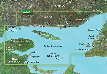
The Garmin VCA007R G3 Vision Les Mechin To St Georges Bay is a marine chart that provides detailed coverage of the Les Mechins to St. Georges Bay area, including the St. Lawrence River and surrounding coastal areas. This chart is part of the Garmin G3 Vision series, which offers advanced features such as 3D views, satellite imagery, and Auto Guidance. With the Garmin VCA007R G3 Vision Les Mechin To St Georges Bay, you’ll have access to a wealth of information to help you navigate the waters with confidence.
The Garmin VCA007R G3 Vision Les Mechin To St Georges Bay provides highly detailed nautical charts, including shaded depth contours, coastlines, and underwater features. It also includes aerial photography, which can help you better understand the layout of the area and make informed decisions about your route. Additionally, the chart is compatible with Garmin’s Auto Guidance feature, which uses your boat’s dimensions and the chart data to provide a suggested route and help you avoid potential hazards.
One of the key benefits of the Garmin VCA007R G3 Vision Les Mechin To St Georges Bay is its ability to provide a clear and detailed picture of the underwater environment. This can be especially useful for fishermen, who can use the chart to locate structure and find the best fishing spots. The chart also includes information on tides, currents, and other environmental factors, which can help you plan your trip and stay safe on the water.
Why pick the Garmin VCA007R G3 Vision Les Mechin To St Georges Bay:
- Provides detailed coverage of the Les Mechins to St. Georges Bay area, including the St. Lawrence River and surrounding coastal areas.
- Offers advanced features such as 3D views, satellite imagery, and Auto Guidance.
- Includes highly detailed nautical charts, including shaded depth contours, coastlines, and underwater features.
Where to use it:
- Les Mechins to St. Georges Bay area
- St. Lawrence River
- Surrounding coastal areas
Tips for maintenance:
- Regularly update your chart to ensure you have the latest information.
- Use the chart in conjunction with other navigation tools, such as GPS and radar.
- Take advantage of the chart’s advanced features, such as 3D views and Auto Guidance, to get the most out of your navigation experience.













Reviews
Clear filtersThere are no reviews yet.