Garmin VUS513L G3 Vision Jacksonville – Bahamas
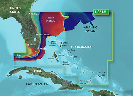
The Garmin VUS513L G3 Vision Jacksonville – Bahamas is a high-quality marine chart that provides detailed coverage of the Jacksonville area, including the St. Johns River, Nassau Sound, and the Atlantic coast of Florida, as well as the Bahamas. This chart is designed for use with Garmin GPS chart plotters and offers a range of features to help you navigate the waters with confidence.
With the Garmin VUS513L G3 Vision Jacksonville – Bahamas, you’ll have access to a range of advanced features, including 3D views, Auto Guidance, and enhanced fishing charts. The chart also includes detailed information on buoys, lights, beacons, and other aids to navigation, as well as marinas, harbors, and other points of interest.
The Garmin VUS513L G3 Vision Jacksonville – Bahamas is a must-have for any mariner who wants to explore the waters of Jacksonville and the Bahamas. With its detailed coverage and advanced features, this chart is sure to become an essential tool in your navigation arsenal. Whether you’re a seasoned sailor or just starting out, the Garmin VUS513L G3 Vision Jacksonville – Bahamas has got you covered.
The Garmin VUS513L G3 Vision Jacksonville – Bahamas is compatible with a range of Garmin devices, including the GPSMAP 7×2, 9×2, and 12×2 series, as well as the quatix series. It’s also compatible with the Garmin ActiveCaptain app, which allows you to access a range of additional features and tools.
Why pick the Garmin VUS513L G3 Vision Jacksonville – Bahamas?
- Get detailed coverage of the Jacksonville area and the Bahamas
- Enjoy advanced features like 3D views and Auto Guidance
- Take advantage of enhanced fishing charts and detailed information on aids to navigation
Where to use it
The Garmin VUS513L G3 Vision Jacksonville – Bahamas is perfect for mariners who want to explore the waters of Jacksonville and the Bahamas. Whether you’re sailing, fishing, or just cruising, this chart has got you covered.
Tips for maintenance
To get the most out of your Garmin VUS513L G3 Vision Jacksonville – Bahamas, make sure to regularly update your chart data and keep your device’s software up to date. It’s also a good idea to clean your device’s screen regularly to ensure optimal performance.
By following these tips and using the Garmin VUS513L G3 Vision Jacksonville – Bahamas, you’ll be able to navigate the waters with confidence and enjoy a range of advanced features that will take your boating experience to the next level.
The Garmin VUS513L G3 Vision Jacksonville – Bahamas is a high-quality marine chart that is designed to meet the needs of mariners in the Jacksonville area and the Bahamas. With its detailed coverage and advanced features, this chart is an essential tool for anyone who wants to explore the waters with confidence.











Reviews
Clear filtersThere are no reviews yet.