

Garmin VCA006R G3 Vision P.E.I To Chaleur Bay – Best & Worst Features
Introduction
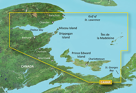
The Garmin VCA006R G3 Vision P.E.I To Chaleur Bay is an advanced marine navigation card designed for boaters who demand precision, safety, and ease of use. Covering the coastal regions from Prince Edward Island to Chaleur Bay, this chart provides unparalleled detail, including high-resolution satellite imagery, 3D views, auto guidance, and rich navigational data. Whether you’re an experienced captain or a recreational boater, this tool is essential for navigating challenging waters with confidence.
With its integration into Garmin’s premium chartplotters, the VCA006R G3 Vision enhances your on-water experience by combining cutting-edge cartography with practical, real-time data. Its features make it a top choice for boat owners who frequent the Canadian Maritimes and surrounding waters.
Overview / What Is Garmin VCA006R G3 Vision P.E.I To Chaleur Bay?
The Garmin VCA006R G3 Vision P.E.I To Chaleur Bay is a specialized cartography card that works with compatible Garmin chartplotters to provide enhanced marine navigation features. It includes highly detailed BlueChart® g3 Vision data, which combines the best of Garmin and Navionics® content. This coverage area specifically focuses on the maritime zones around Prince Edward Island and Chaleur Bay, providing boaters with crucial charting details for safe travel.
With this product, users gain access to features such as Auto Guidance+, aerial photos, satellite imagery, 3D MarinerEye and FishEye views, and advanced fishing charts. These enhancements are particularly valuable when maneuvering in unfamiliar waters or near complex coastal structures.
Key Features of Garmin VCA006R G3 Vision
Here are the standout features that make this product highly recommended for boaters:
- Detailed Cartography: Includes high-resolution charts with accurate depth contours and navigational aids.
- 3D Views: MarinerEye and FishEye perspectives offer a realistic view of the underwater and above-water environment.
- Auto Guidance+ Technology: Automatically suggests the optimal route based on your boat’s specifications and safe depth parameters.
- Satellite Imagery: Overlay real-world satellite images for improved situational awareness.
- Fishing Charts: Target fish with high-resolution bathymetric data that reveals bottom structure.
Why Choose Garmin VCA006R G3 Vision for Your Boat?
For boaters navigating the Gulf of St. Lawrence, the choice of a reliable and feature-rich marine chart is critical. The Garmin VCA006R G3 Vision P.E.I To Chaleur Bay not only ensures safe passage but also enhances your boating experience with tools that assist in fishing, docking, and cruising.
Compared to standard charts, Vision cards offer superior features, making them ideal for demanding users who want every advantage while exploring complex waterways.
Maintenance Tips
To maximize the life and performance of your Garmin VCA006R G3 Vision P.E.I To Chaleur Bay, follow these maintenance tips:
- Keep the SD card clean and free of dust or moisture. Store it in its protective case when not in use.
- Regularly update your Garmin device software to ensure compatibility with the latest chart enhancements.
- Avoid exposing the card to extreme temperatures or direct sunlight for prolonged periods.
- Make backups of important routes and waypoints on an external device to prevent data loss.
Proper care ensures that your investment continues to deliver accurate navigation for years to come.
How to Use Garmin VCA006R G3 Vision Effectively
Using this chart is straightforward. Insert the SD card into your compatible Garmin chartplotter, and the enhanced maps will automatically load. You can then access advanced features like Auto Guidance, view satellite overlays, and zoom in on areas of interest. Be sure to configure your vessel’s specifications for accurate route suggestions.
For first-time users, refer to the product manual for detailed installation and usage instructions. Additionally, you can explore tutorials on Garmin’s official website or partner resources like Yamaha Outboards to get tips on integrating advanced navigation with your boat’s systems.
Expert Advice and Pro Recommendations
Experts recommend pairing the Garmin VCA006R G3 Vision P.E.I To Chaleur Bay with a high-performance Garmin chartplotter to unlock its full potential. This combination ensures seamless updates, fast loading maps, and enhanced navigational accuracy. Professional anglers particularly benefit from the advanced fishing charts included in this package.
Buy now and experience the benefits of advanced cartography: Garmin VCA006R G3 Vision P.E.I To Chaleur Bay and enjoy 5% off using code WELCOME5.
Detailed FAQ Section
1. What makes Garmin VCA006R G3 Vision different from regular charts?
The Garmin VCA006R G3 Vision P.E.I To Chaleur Bay stands out due to its integration of high-definition satellite imagery, 3D views, and Auto Guidance+ features. Unlike regular charts, this Vision card provides real-time navigational aids, photorealistic views, and fishing-specific data. These additions enhance safety and efficiency, giving boaters confidence when traveling in complex waters. Regular charts may only provide basic contours and navigation markers, whereas the Vision version offers a more immersive and data-rich experience. By investing in this product, users enjoy advanced mapping capabilities tailored to both recreational and professional boating needs.
2. How do I install the Garmin VCA006R G3 Vision card?
Installation is simple: insert the SD card into your compatible Garmin chartplotter’s card slot. The device will automatically detect and load the enhanced maps. Make sure your chartplotter firmware is updated to avoid compatibility issues. Once installed, configure your vessel’s parameters (such as draft and height) for optimal Auto Guidance routing. For maximum performance, avoid using counterfeit or outdated cards. If you face issues, refer to Garmin’s support or consult online forums where experienced boaters share tips on troubleshooting. This ease of installation makes the Vision series highly user-friendly for all boaters.
3. Is the Garmin VCA006R G3 Vision worth the investment?
Absolutely. For boaters navigating between Prince Edward Island and Chaleur Bay, this card provides unmatched accuracy, coverage, and advanced features that enhance safety. The inclusion of aerial photos, satellite imagery, and fishing-specific data gives you an edge over standard charts. While the initial cost may be higher, the long-term benefits in terms of reduced risk and improved navigation justify the investment. Furthermore, frequent updates ensure that your charts remain current with the latest navigational data. Whether for commercial use or leisure, the product offers exceptional value for its price.
4. Can I use this card with all Garmin devices?
The Garmin VCA006R G3 Vision P.E.I To Chaleur Bay is compatible with most modern Garmin chartplotters that support BlueChart g3 Vision. However, older devices may not fully utilize all features, such as 3D views or Auto Guidance+. Before purchasing, check your device’s specifications to ensure compatibility. Using the card with the recommended models ensures smooth performance and access to all premium features. If you’re unsure, consult Garmin’s official compatibility list or reach out to your dealer for guidance. Compatibility is a crucial factor in getting the most out of this advanced cartography card.
5. How often should I update my Garmin VCA006R G3 Vision?
It’s recommended to update your charts at least once a year or whenever Garmin releases significant updates. Keeping your maps updated ensures you have access to the latest navigation data, safety markers, and newly added features. Updates can be purchased through Garmin’s website or authorized dealers. Regular updates are essential for safe navigation, especially in dynamic coastal environments where hazards and structures may change over time. By staying current, you maximize the accuracy and reliability of your navigation system, ensuring safe and enjoyable boating experiences year after year.
Conclusion
The Garmin VCA006R G3 Vision P.E.I To Chaleur Bay stands as a top-tier choice for boaters seeking enhanced navigation, safety, and convenience. Its advanced features, easy installation, and compatibility with modern Garmin devices make it indispensable for anyone navigating the Canadian Maritimes. Whether you’re fishing, cruising, or exploring new waters, this product delivers the precision you need.
Special Offer
WELCOME5 – Get 5% off storewide at allboatsupplies.com
🚀 Instant Assistance: Need help selecting the right product? Drop your contact in the chatbox at the bottom right corner, and our expert team will reply within 30 minutes with the best product suggestion for your boat — including a ready-to-use checkout link. We’re fast, knowledgeable, and always here for your boating needs!
No more guesswork — just message us and get a personalized checkout link for your antifouling system, fast!
Explore Our Best-Selling Ultrasonic Antifouling Products:
Buy now
Garmin VCA006R G3 Vision P.E.I To Chaleur Bay
Let us handle the hassle — expert support, quick replies, and smooth checkout. Your boat deserves the best.
Read More
For more helpful marine maintenance guides, check out our article on Garmin Trim Snap Covers Ultra12 Easy & Secure Fit.