C-MAP M-NA-D930 4D Local Lake Superior
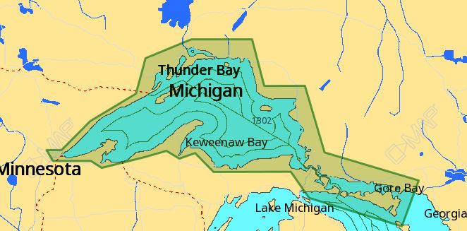
The C-MAP M-NA-D930 4D Local Lake Superior is a high-performance chartplotter map that provides detailed and accurate charts for boaters and anglers. This C-MAP M-NA-D930 4D Local Lake Superior chartplotter map is designed specifically for use on Lake Superior, providing comprehensive coverage of the lake’s waters.
The C-MAP M-NA-D930 4D Local Lake Superior chartplotter map includes advanced features such as 3D views, aerial photography, and detailed harbor charts. With this C-MAP M-NA-D930 4D Local Lake Superior chartplotter map, boaters and anglers can navigate the lake with confidence, identifying hazards, finding fishing hotspots, and exploring hidden coves.
In addition to its advanced features, the C-MAP M-NA-D930 4D Local Lake Superior chartplotter map is also compatible with a range of devices, including Garmin, Humminbird, and Lowrance chartplotters. This means that boaters and anglers can easily transfer their C-MAP M-NA-D930 4D Local Lake Superior chartplotter map to their preferred device, ensuring seamless navigation and planning.
Why pick the C-MAP M-NA-D930 4D Local Lake Superior?
The C-MAP M-NA-D930 4D Local Lake Superior offers several unique benefits, including:
- Highly detailed and accurate charts, providing boaters and anglers with a clear understanding of the lake’s layout and hazards.
- Advanced features such as 3D views and aerial photography, enhancing the navigation experience.
- Compatibility with a range of devices, ensuring flexibility and convenience.
Where to use it
The C-MAP M-NA-D930 4D Local Lake Superior chartplotter map is designed for use on Lake Superior, making it an essential tool for boaters and anglers who frequent this popular fishing destination.
Whether you’re planning a day trip or an extended fishing excursion, the C-MAP M-NA-D930 4D Local Lake Superior chartplotter map provides the detailed information you need to navigate the lake with confidence.
Tips for maintenance
To ensure the C-MAP M-NA-D930 4D Local Lake Superior chartplotter map remains accurate and up-to-date, it’s essential to:
- Regularly update the chartplotter map to ensure access to the latest information and features.
- Store the chartplotter map in a secure location, away from direct sunlight and moisture.
- Handle the chartplotter map with care, avoiding scratches and damage to the device.
By following these simple tips, boaters and anglers can ensure their C-MAP M-NA-D930 4D Local Lake Superior chartplotter map remains a valuable navigation tool for years to come.














Reviews
Clear filtersThere are no reviews yet.