the C-MAP M-NA-D935 4D Local St Lawrence River:
C-MAP M-NA-D935 4D Local St Lawrence River
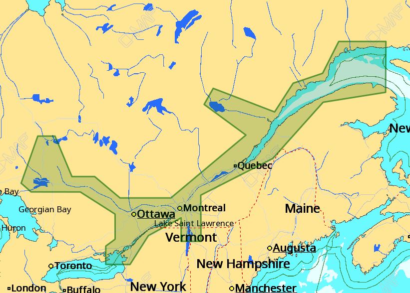
The C-MAP M-NA-D935 4D Local St Lawrence River is a comprehensive electronic chart that provides detailed navigation information for the St Lawrence River. This chart features C-MAP’s patented 4D chart technology, which combines the accuracy of traditional paper charts with the versatility of electronic navigation.
With the C-MAP M-NA-D935 4D Local St Lawrence River, you’ll have access to a wealth of navigation data, including detailed harbor charts, marina information, and navigation aids. The chart also includes 3D views of the seafloor, allowing you to better understand the underwater environment and make more informed navigation decisions.
The C-MAP M-NA-D935 4D Local St Lawrence River is compatible with a wide range of GPS plotters and chart plotters, making it easy to integrate into your existing navigation system. Additionally, the chart is regularly updated to ensure that you have the most accurate and up-to-date information available.
Why pick the C-MAP M-NA-D935 4D Local St Lawrence River:
- Get unparalleled accuracy and detail with C-MAP’s patented 4D chart technology
- Enjoy seamless integration with your existing GPS plotter or chart plotter
- Stay up-to-date with regular chart updates and corrections
- Experience enhanced navigation with detailed harbor charts and marina information
Where to use it:
The C-MAP M-NA-D935 4D Local St Lawrence River is perfect for boaters, fishermen, and sailors who frequent the St Lawrence River. Whether you’re navigating through treacherous waters or simply enjoying a leisurely cruise, this chart provides the detailed information you need to stay safe and on course.
Tips for maintenance:
- Regularly update your chart to ensure you have the latest information
- Store your chart in a safe and dry place when not in use
- Use a high-quality GPS plotter or chart plotter to ensure optimal performance
- Consult the user manual for troubleshooting and maintenance tips
With the C-MAP M-NA-D935 4D Local St Lawrence River, you can navigate the St Lawrence River with confidence and precision. Order your chart today and experience the difference that C-MAP’s patented 4D technology can make!
By choosing the C-MAP M-NA-D935 4D Local St Lawrence River, you can trust that you’re getting the most accurate and reliable navigation information available. The C-MAP M-NA-D935 4D Local St Lawrence River is the perfect choice for anyone who wants to stay safe and on course in the St Lawrence River.
Don’t settle for anything less than the best – choose the C-MAP M-NA-D935 4D Local St Lawrence River for your navigation needs. With its unparalleled accuracy and detail, this chart is the perfect choice for boaters, fishermen, and sailors of all levels.
In conclusion, the C-MAP M-NA-D935 4D Local St Lawrence River is the ultimate navigation tool for anyone who spends time on the St Lawrence River. With its patented 4D technology, detailed harbor charts, and regular updates, this chart provides the accuracy and reliability you need to stay safe and on course.



















Reviews
Clear filtersThere are no reviews yet.