the C-MAP NA-C502 Western Caribbean Sea:
C-MAP NA-C502 Western Caribbean Sea
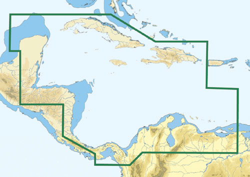
The C-MAP NA-C502 Western Caribbean Sea is a marine chart that provides detailed coverage of the Western Caribbean Sea, including the coasts of Mexico, Belize, Guatemala, Honduras, El Salvador, Nicaragua, Costa Rica, and Panama. This chart is ideal for cruisers, fishermen, and sailors who need accurate and reliable navigation data.
The C-MAP NA-C502 Western Caribbean Sea offers advanced features such as 3D charts, tides and currents, and aerial photos, making it an essential tool for anyone exploring this region. With the C-MAP NA-C502 Western Caribbean Sea, you’ll have access to a wealth of information, including harbor charts, fishing guides, and points of interest.
Whether you’re navigating through the crystal-clear waters of the Caribbean or exploring the scenic coastlines of Central America, the C-MAP NA-C502 Western Caribbean Sea has got you covered. This chart is compatible with a wide range of GPS plotters and chart plotters, ensuring seamless integration and ease of use.
Why pick the C-MAP NA-C502 Western Caribbean Sea:
- Provides detailed coverage of the Western Caribbean Sea and Central American coastlines
- Offers advanced features such as 3D charts, tides and currents, and aerial photos
- Ideal for cruisers, fishermen, and sailors who need accurate and reliable navigation data
- Compatible with a wide range of GPS plotters and chart plotters
Where to use it:
The C-MAP NA-C502 Western Caribbean Sea is perfect for:
- Cruising the Caribbean Sea and exploring its many islands
- Fishing in the waters of Mexico, Belize, and Central America
- Sailing through the scenic coastlines of Costa Rica and Panama
- Navigating through the Panama Canal
Tips for maintenance:
To ensure optimal performance and accuracy, it’s essential to:
- Regularly update your chart with the latest data
- Keep your GPS device clean and free of debris
- Store your chart in a protective case when not in use
- Consult the user manual for troubleshooting and maintenance tips
The C-MAP NA-C502 Western Caribbean Sea is an essential tool for anyone exploring this beautiful region. With its advanced features and detailed coverage, you’ll be able to navigate with confidence and accuracy. So why wait? Get your C-MAP NA-C502 Western Caribbean Sea today and start planning your next adventure!
Remember, the C-MAP NA-C502 Western Caribbean Sea is the perfect choice for cruisers, fishermen, and sailors who need accurate and reliable navigation data. Its advanced features, detailed coverage, and compatibility with a wide range of GPS plotters and chart plotters make it an essential tool for anyone exploring the Western Caribbean Sea and Central American coastlines.
Order your C-MAP NA-C502 Western Caribbean Sea now and start exploring the beauty of the Caribbean Sea and Central America with confidence!
With the C-MAP NA-C502 Western Caribbean Sea, you’ll have access to a wealth of information, including harbor charts, fishing guides, and points of interest. So why settle for anything less? Get the C-MAP NA-C502 Western Caribbean Sea today and experience the difference for yourself!
















Reviews
Clear filtersThere are no reviews yet.