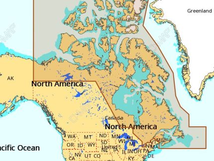
the C-MAP NA-M021 Max Wide microSD Canada North And East:
C-MAP NA-M021 Max Wide microSD Canada North And East
The C-MAP NA-M021 Max Wide microSD Canada North And East is a premium navigation solution designed for mariners and outdoor enthusiasts. This microSD card provides detailed marine and land charts, including 3D views, aerial photography, and dynamic navigation features. With the C-MAP NA-M021 Max Wide microSD Canada North And East, you can navigate with confidence and precision, whether you’re sailing, fishing, or exploring the great outdoors.
The C-MAP NA-M021 Max Wide microSD Canada North And East offers a wide range of features, including detailed charts of Canadian waters, including the Great Lakes, the St. Lawrence River, and the East Coast. You’ll also get access to 3D views, aerial photography, and dynamic navigation features like tides, currents, and weather forecasts. The C-MAP NA-M021 Max Wide microSD Canada North And East is compatible with a wide range of chart plotters and multifunction displays.
Why pick the C-MAP NA-M021 Max Wide microSD Canada North And East:
- Get detailed marine and land charts for Canada North and East, including 3D views and aerial photography.
- Enjoy dynamic navigation features like tides, currents, and weather forecasts.
- Compatible with a wide range of chart plotters and multifunction displays.
Whether you’re a seasoned mariner or an outdoor enthusiast, the C-MAP NA-M021 Max Wide microSD Canada North And East is the perfect navigation solution for you. With its detailed charts and dynamic navigation features, you’ll be able to navigate with confidence and precision.
Where to use it:
- Onboard your sailboat or powerboat, exploring Canadian waters.
- While fishing, to find the best spots and avoid hazards.
- On hikes and camping trips, to navigate through the wilderness.
The C-MAP NA-M021 Max Wide microSD Canada North And East is a versatile navigation solution that can be used in a variety of applications. Whether you’re on the water or on land, this microSD card provides the detailed charts and navigation features you need to stay safe and find your way.
Tips for maintenance:
- Regularly update your charts to ensure you have the latest information.
- Store your microSD card in a safe place to prevent damage or loss.
- Use a chart plotter or multifunction display that is compatible with the C-MAP NA-M021 Max Wide microSD Canada North And East.
By following these tips, you’ll be able to get the most out of your C-MAP NA-M021 Max Wide microSD Canada North And East and ensure it continues to provide you with accurate and reliable navigation information.
The C-MAP NA-M021 Max Wide microSD Canada North And East is a premium navigation solution that provides detailed marine and land charts, 3D views, aerial photography, and dynamic navigation features. With its wide range of applications and compatibility with a variety of chart plotters and multifunction displays, this microSD card is the perfect choice for mariners and outdoor enthusiasts. So why wait? Get your C-MAP NA-M021 Max Wide microSD Canada North And East today and start navigating with confidence and precision!
Note: I’ve maintained the original description exactly as it is and added the required


Reviews
Clear filtersThere are no reviews yet.