the C-MAP NA-M022 Max Wide microSD East Coast And Bahamas:
C-MAP NA-M022 Max Wide microSD East Coast And Bahamas
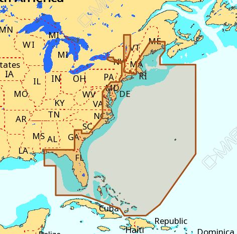
The C-MAP NA-M022 Max Wide microSD East Coast And Bahamas is a high-performance chart card that provides detailed and accurate navigation data for the East Coast and Bahamas region. This microSD card is designed for use with compatible GPS plotters and chart plotters, offering a wide range of features and benefits for boaters, sailors, and fishermen.
With the C-MAP NA-M022 Max Wide microSD East Coast And Bahamas, you can enjoy safe and confident navigation with access to detailed charts, including buoys, beacons, and other navigation aids. The card also features a high-resolution bathymetric database, providing detailed information on water depths and contours.
The C-MAP NA-M022 Max Wide microSD East Coast And Bahamas is an essential tool for anyone planning to explore the East Coast and Bahamas region. Whether you’re a casual boater or a seasoned sailor, this chart card provides the accuracy and reliability you need to navigate with confidence.
Why pick the C-MAP NA-M022 Max Wide microSD East Coast And Bahamas:
- Provides detailed and accurate navigation data for the East Coast and Bahamas region
- Offers a wide range of features and benefits for boaters, sailors, and fishermen
- Designed for use with compatible GPS plotters and chart plotters
Where to use it:
The C-MAP NA-M022 Max Wide microSD East Coast And Bahamas is perfect for anyone planning to explore the East Coast and Bahamas region, including:
- Boaters and sailors navigating the coastal waters of the East Coast
- Fishermen targeting specific species in the Bahamas
- Cruisers exploring the islands and cays of the Bahamas
Tips for maintenance:
To ensure optimal performance and longevity of your C-MAP NA-M022 Max Wide microSD East Coast And Bahamas, follow these tips:
- Regularly update your chart card to ensure access to the latest charts and data
- Handle the microSD card with care to avoid damage or corruption
- Store the card in a safe and dry place when not in use
The C-MAP NA-M022 Max Wide microSD East Coast And Bahamas is a reliable and accurate navigation tool that provides boaters, sailors, and fishermen with the confidence they need to explore the East Coast and Bahamas region. With its detailed charts, high-resolution bathymetric database, and wide range of features, this chart card is an essential tool for anyone planning to venture into these waters.
In conclusion, the C-MAP NA-M022 Max Wide microSD East Coast And Bahamas is a must-have for anyone serious about navigation and safety on the water. With its unparalleled accuracy and reliability, this chart card is the perfect choice for boaters, sailors, and fishermen of all levels.















Reviews
Clear filtersThere are no reviews yet.