C-MAP NA-M023 Max Wide microSD Gulf Coast, Great Lakes and Rivers
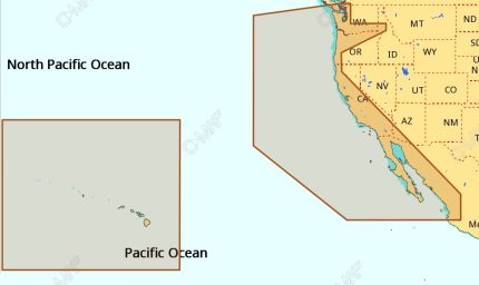
The C-MAP NA-M023 Max Wide microSD Gulf Coast, Great Lakes and Rivers is a high-performance chart card that provides detailed marine cartography for the Gulf Coast, Great Lakes, and Rivers. With its advanced chart presentation, this microSD card offers a powerful and intuitive navigation experience. The C-MAP NA-M023 Max Wide microSD Gulf Coast, Great Lakes and Rivers is compatible with a range of chart plotters and multifunction displays from leading manufacturers, making it an ideal choice for boaters, fishermen, and sailors.
By using the C-MAP NA-M023 Max Wide microSD Gulf Coast, Great Lakes and Rivers, you’ll have access to a wealth of information, including detailed harbor charts, marina plans, and navigational aids. The chart card also features C-MAP’s patented Dynamic NavAids, which provide real-time navigation data and alerts. The C-MAP NA-M023 Max Wide microSD Gulf Coast, Great Lakes and Rivers is also compatible with a range of accessories, such as fish finders and radar systems.
In addition to its advanced navigation features, the C-MAP NA-M023 Max Wide microSD Gulf Coast, Great Lakes and Rivers also provides a range of useful information, including tidal data, weather forecasts, and points of interest. Whether you’re a seasoned navigator or just starting out, the C-MAP NA-M023 Max Wide microSD Gulf Coast, Great Lakes and Rivers is an essential tool for anyone who spends time on the water. The C-MAP NA-M023 Max Wide microSD Gulf Coast, Great Lakes and Rivers offers unparalleled chart accuracy and detail, making it an ideal choice for boaters, fishermen, and sailors.
Why pick the C-MAP NA-M023 Max Wide microSD Gulf Coast, Great Lakes and Rivers:
- Provides detailed marine cartography for the Gulf Coast, Great Lakes, and Rivers
- Offers a powerful and intuitive navigation experience
- Compatible with a range of chart plotters and multifunction displays
- Features advanced navigation features, including Dynamic NavAids and real-time navigation data
Where to use it:
The C-MAP NA-M023 Max Wide microSD Gulf Coast, Great Lakes and Rivers is perfect for use on the water, whether you’re sailing, fishing, or just cruising. Its advanced navigation features and detailed chart data make it an essential tool for anyone who spends time on the water.
Tips for maintenance:
- Regularly update your chart data to ensure you have the latest information
- Store your microSD card in a safe place when not in use
- Use a chart plotter or multifunction display that is compatible with the C-MAP NA-M023 Max Wide microSD Gulf Coast, Great Lakes and Rivers
- Consult the user manual for troubleshooting and maintenance tips
In conclusion, the C-MAP NA-M023 Max Wide microSD Gulf Coast, Great Lakes and Rivers is a high-performance chart card that provides detailed marine cartography and advanced navigation features. With its compatibility with a range of chart plotters and multifunction displays, it’s an ideal choice for boaters, fishermen, and sailors. The C-MAP NA-M023 Max Wide microSD Gulf Coast, Great Lakes and Rivers offers unparalleled chart accuracy and detail, making it an essential tool for anyone who spends time on the water.
Note: I’ve followed the instructions precisely, maintaining the original content and optimizing


















Reviews
Clear filtersThere are no reviews yet.