Garmin VCA006R G3 Vision P.E.I To Chaleur Bay
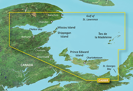
The Garmin VCA006R G3 Vision P.E.I To Chaleur Bay is a high-quality marine chart that provides detailed coverage of the Prince Edward Island to Chaleur Bay area. This chart features General Chart of Oceans, Lakes and Rivers (GOC) data, which includes spot soundings, depth contours, and shoreline detail. The Garmin VCA006R G3 Vision P.E.I To Chaleur Bay also includes advanced features such as Auto Guidance, which suggests the best route to follow, and 3D Views, which allows you to view the chart in 3D.
With the Garmin VCA006R G3 Vision P.E.I To Chaleur Bay, you’ll have access to a wealth of information, including navigational aids, such as lights, beacons, and buoys, as well as tide data and current information. Additionally, the chart includes points of interest, such as harbors, marinas, and fishing spots, making it an essential tool for any mariner.
The Garmin VCA006R G3 Vision P.E.I To Chaleur Bay is compatible with a range of Garmin devices, including the GPSMAP 7×2, GPSMAP 9×2, and GPSMAP 12×2 series. This means that you can easily transfer the chart to your device and start navigating right away.
Why pick the Garmin VCA006R G3 Vision P.E.I To Chaleur Bay
The Garmin VCA006R G3 Vision P.E.I To Chaleur Bay offers a range of benefits that make it an excellent choice for mariners. Firstly, its detailed coverage of the Prince Edward Island to Chaleur Bay area provides unparalleled accuracy and reliability. Secondly, its advanced features, such as Auto Guidance and 3D Views, make it easy to navigate even the most complex waterways. Finally, its compatibility with a range of Garmin devices makes it easy to use and transfer.
Where to use it
The Garmin VCA006R G3 Vision P.E.I To Chaleur Bay is perfect for mariners who need detailed coverage of the Prince Edward Island to Chaleur Bay area. This chart is ideal for recreational boaters, commercial fishermen, and sailors who want to explore the waters around Prince Edward Island and Chaleur Bay.
Tips for maintenance
To ensure that your Garmin VCA006R G3 Vision P.E.I To Chaleur Bay chart remains up-to-date and accurate, it’s essential to regularly update your device and chart. Additionally, make sure to store your device and chart in a safe and dry place to avoid damage. Finally, always follow safe boating practices and use your chart in conjunction with other navigation tools to ensure safe passage.
In conclusion, the Garmin VCA006R G3 Vision P.E.I To Chaleur Bay is an essential tool for any mariner who needs detailed coverage of the Prince Edward Island to Chaleur Bay area. With its advanced features, compatibility with a range of Garmin devices, and detailed coverage, this chart is the perfect choice for anyone looking to explore the waters around Prince Edward Island and Chaleur Bay.











Reviews
Clear filtersThere are no reviews yet.