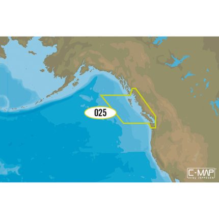
C-MAP M-NA-D021 4D microSD
Canada North And East
Model: M-NA-D021-MS
- Toggle different views on and off to see animated tidal streams, currents and flows on your map. When planning your trip, check out the tidal heights so you won’t be caught off-guard by sudden changes. Dynamic navigational aids give you the tools you need to plan and master your route.
- Depths and land elevation, photos, diagrams and bird’s eye view perspective options let you choose your view.
- View coastal roads and Points of Interest such as restaurants, museums, local services and cultural highlights.
- Get detailed marina port plans and harbor charts so docking is a breeze even on your first visit!
- Keep safety in mind, but rest easy with Guardian Alarm settings that will let you know about rocks, obstructions, shallow depths and other navigation hazards.
- Crowd sourced and directly from C-MAP trusted sources, these daily updates will give you the confidence to navigate unfamiliar waters. The first year’s on us!
- Add high-resolution bathymetry charts and details about Marine Protected Area so your have all the information you need at your fingertips.
Dominate the water with C-MAP’s full vector charts, harbor and approach details, tide and current tools, and more.
Full-Feature Vector Charts give you tools like tidal streams, detailed roads, and accurate marina plans, giving you the utmost situational awareness in your covered area.
High-Definition Aerial Photography will ensure you get the best view of where you are and where you’re going even in sub-optimal conditions.
Expandability is built-in to these cards via Value Added Data Segments (sold separately) so that when you need that extra local detail, adding it to the charts you already use is hassle-free.
One Free Year of daily updates means you will have the most accurate, up-to-date information available, keeping you and your crew safe out on the water.
Coverage:
The Arctic and Atlantic coasts of Canada
Includes: Hudson Bay, Newfoundland, the Gulf of St. Lawrence, Nova Scotia; The Bay of Fundy; The St. Lawrence River; Eastern Lake Ontario; All of Passamaquoddy Bay


Reviews
Clear filtersThere are no reviews yet.