C-MAP M-NA-D954 4D Local Cape Blanco - Cape Flattery
$229.77 Original price was: $229.77.$207.00Current price is: $207.00.
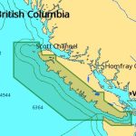
C-MAP M-NA-D956 4D Local Victoria BC - Cape Scott
$229.77 Original price was: $229.77.$207.00Current price is: $207.00.
-10%Sold out

Fast delivery within 72 Hours
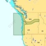
C-MAP M-NA-D955 4D Local Puget Sound San Juan Islands
$229.77 Original price was: $229.77.$207.00Current price is: $207.00.
Out of stock
SKU:
WT-CMANAD955
Category: C-MAP-4D CHARTS
Brands:
C-Map
“C-MAP M-NA-D955 MS 4D Local Chart for Puget Sound and San Juan Islands, compatible with Furuno, Standard Horizon, and Humminbird, provides stunning 3D views, satellite imagery, and detailed vector chart data for a safer and more enjoyable boating experience, including outboard lower unit navigation.”
Description
Developed by Jeppesen for your favorite style of boating, C-MAP 4D represents the latest evolution of electronic charting technology. C-MAP 4D combines our award-winning vector chart data with Dynamic Raster Charts for stunningly detailed 3D views and satellite imagery. Our innovative features include unique content and exclusive Value Added Data to enhance each cruising, fishing or sailing experience. C-MAP 4D truly is your all-in-one charting solution, compatible with select chartplotters from Furuno, Standard Horizon and Humminbird.
C-MAP 4D Wide and 4D Local charts provide a wealth of features that make navigation safer, fishing more productive and cruising more fun. The following features table shows the many ways C-MAP 4D can make your boating experience better and more efficient.
This table shows the chart information that is included in the C-MAP 4D product.
| 4D FEATURES | WIDE – LOCAL |
|---|---|
| Raster Charts Traditional ?paper chart? look with unique ability to access information on buoys, lights and other details. | X |
| 3D Views Stunning three-dimensional views of land elevation and bottom contours bring the world around (and under) your boat to life. | X |
| Satellite Images High-resolution satellite imagery provides real-world reference, enhances situational awareness for coastal navigation. | X |
| Easy Routing Automatically plots the shortest, safest route based on detailed chart data and user vessel information. | X |
| Vector Cartography Provides a wealth of chart detail with the versatility to customize data layers and how they are viewed. | X |
| Tides, Currents and Animated Tidal Flows Interactive on-screen tide graphs and current arrows. | X |
| Aerial Photos Arial pictures of harbor entrances, channels and marinas. | X |
| California MPAs Boundaries and regulations showing all current Marine Protected Areas in California. | X |
| Coastal (Topographical) features Primary and secondary roads, points of intereset and unique land-elevation shading. | X |
| Detailed Marina Charts Depictions of actual marina layouts showing facility and amenity locations (hoist, fuel dock, water hookups) as well as dock labels. | X |
| Guardian Alarm Search and receive alerts for rocks, obstructions, shallow depths and other navigation hazards. | X |
| Multi-Language Charts More than 140 languages can be displayed using native character sets. | X |
| Value Added Data* | X |
| High-Res Bathy Charts The highest detail of underwater pinnacles, ledges and canyons that are magnets for offshore and coastal gamefish. | X |
| Sports Fishing Data Provides angling intelligence for wrecks and reefs, gamefish ID photos, fishing tips and techniques, regulations, state records and more. | X |
* Value Added Data can be purchased and unlocked through our web store, or an authorized Jeppesen Dealer.
C-MAP 4D Local charts are an affordable option designed to exceed your most stringent cruising, sailing and fishing expectations. Don?t be fooled by the name ? these charts cover large areas of U.S., Canadian, and Mexican coastal waters, as well as the Bahamas, Great lakes and the St. Lawrence River. With a C-MAP 4D Local chart in a compatible OEM partner chartplotter, you can enjoy extended time on the water and seek adventure both near and far.
Additional information
| Weight | 0.1 lbs |
|---|---|
| Google Part Number |
M-NA-D955-MS |
| Google Product Category |
3391 |