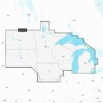
Navionics Platinum+ NPUS005R U.S. North microSD
Model: 010-C1368-40
- Integrated Garmin and Navionics® content provides exceptional coverage, clarity and detail in a familiar look and feel
- Easy access to daily chart updates is available via the Navionics® Chart Installer software or wirelessly via the Plotter Sync feature with the Navionics Boating app (The Plotter Sync feature requires use of the Navionics Boating app on your compatible smart device with an active subscription of the same area.)
- Navionics® advanced dock-to-dock route guidance technology uses your boat settings, along with chart data and frequently traveled routes, to calculate a suggested path to follow (Route guidance is for planning purposes only and does not replace safe navigation operations.)
- High-resolution relief shading feature combines color and shadow to give you an easy-to-interpret, clearer view of bottom structure than contour lines alone
- High-resolution satellite imagery combined with SonarChart™ Shading overlay give you a realistic view of your surroundings — ideal for entering unfamiliar harbors or ports
- Sonar imagery is a downloadable image overlay that shows bottom hardness in contrasting color so you can easily identify transition areas on select U.S. lakes
- Aerial and surface photography of ports, marinas, bridges, docks, boat ramps, dams and navigational landmarks offers superior situational awareness
- Unique 3D views provide additional perspective both above and below the water
- Download the Community Edits content layer to any Navionics® card, and view this valuable, local information — contributed by Navionics Boating app users — on your compatible chartplotter
- For improved fishing and navigation, SonarChart™ HD bathymetry maps display up to 1’ (0.5 meter) contours, providing a more detailed depiction of bottom structure
- Fishing range advanced feature lets you highlight a user-defined target depth range
- To aid in navigation, the shallow water shading advanced feature highlights depths up to a user-defined level
- SonarChart™ Live mapping feature allows boaters to create new personal 1’ HD bathymetry maps that display in real time on the screens of their compatible plotters while navigating
Detailed coverage of the lakes and rivers of Iowa, Michigan, Minnesota, North Dakota, South Dakota, Wisconsin, and the U.S. waters of the Great Lakes that border those states.
Get the world’s No. 1 choice in marine mapping (based on 2020 reported sales) — with the best, most up-to-date Navionics Platinum+™ premium marine cartography on your compatible chartplotter. For offshore or inland waters, this all-in-one solution offers detail-rich integrated mapping of coastal waters, lakes, rivers and more. Get 1’ (0.5 meter) HD contours, premier-grade chart features (depending on chartplotter model), including high-resolution relief shading, satellite imagery with SonarChart™ Shading overlay and 3D views, plus dock-to-dock route guidance technology, live mapping and Plotter Sync to provide wireless access to daily updates. The Navionics® Chart Installer software also ensures access to the freshest chart data every time out. Navionics route guidance solutions give you a suggested path to follow through channels, inlets, marina entrances and more. (Route guidance is for planning purposes only and does not replace safe navigation operations.) Multiple shading options aid in shallow water navigation and make it easy to highlight a target depth range for the best fishing spots.