


Navionics Platinum+ NPUS012R Canada Great Lakes microSD Review
Navionics Platinum+ NPUS012R Canada, East and Great Lakes microSD for Boats & Marine Engines
Introduction
The Navionics Platinum+ NPUS012R Canada, East and Great Lakes microSD is a top-tier marine charting solution designed for boating enthusiasts and professionals navigating Canadian eastern waters and the Great Lakes. This advanced chart card integrates highly detailed cartography, advanced 3D mapping, and dynamic features to enhance your navigation experience. Whether you are a fisherman, a recreational boater, or a marine professional, this product ensures you have the best possible data to plan and execute safe journeys. In this article, we will cover every detail of the NPUS012R, including its features, usage, maintenance tips, expert advice, and answers to common questions.
Overview / What Is Navionics Platinum+ NPUS012R?
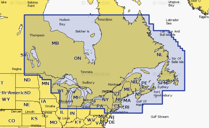
The Navionics Platinum+ NPUS012R Canada, East and Great Lakes microSD is part of the Navionics Platinum+ series, offering unparalleled chart detail and a suite of interactive features. It is designed to cover an extensive area, including Canadian eastern coastal waters and the Great Lakes, providing boaters with accurate navigation data, depth contours, 3D views, and satellite overlays.
This microSD card is compatible with a wide range of chartplotters, ensuring flexibility for different boat setups. With regularly updated charts, it provides the most current information on marine features, hazards, and navigation aids, making it a reliable companion for any voyage.
Key Features of Navionics Platinum+ NPUS012R
- Extensive Coverage: Includes Canadian eastern waters and all Great Lakes regions.
- 3D Charting: Advanced 3D views enhance navigation accuracy.
- Satellite Overlay: High-resolution satellite imagery improves situational awareness.
- SonarChart: High-definition bathymetry maps for detailed underwater views.
- Community Edits: Access user-generated updates and corrections.
- Dock-to-Dock Auto Routing: Simplifies route planning with intelligent path suggestions.
Why Choose Navionics Platinum+ NPUS012R for Your Boat?
Choosing the right marine chart is critical for safe and efficient navigation. The Navionics Platinum+ NPUS012R offers a comprehensive solution with accurate and detailed cartography. Unlike standard charts, Platinum+ series includes unique features such as panoramic port photos, 3D mapping, and sonar charts that bring a new level of confidence to your trips. The regular updates ensure you always have the latest information at your fingertips.
Boaters who frequent the eastern Canadian coastline or the Great Lakes will find this card particularly beneficial, as it covers all major fishing hotspots, harbors, and routes. Its compatibility with popular chartplotters makes it a versatile choice for various marine setups.
How to Install and Use Navionics Platinum+ NPUS012R?
Installing the Navionics Platinum+ NPUS012R Canada, East and Great Lakes microSD is a straightforward process:
- Ensure your chartplotter is compatible with Navionics Platinum+ microSD cards.
- Insert the card into the device’s SD slot while the unit is powered off.
- Power on the chartplotter and follow on-screen prompts to load charts.
- Register the product on the Navionics website for updates and additional features.
After installation, you can easily access chart layers, toggle between 2D and 3D views, and plan your routes using the card’s advanced features. For enhanced performance, regularly update the chart data using the Navionics Chart Installer software.
Maintenance Tips
Proper maintenance of the Navionics Platinum+ NPUS012R Canada, East and Great Lakes microSD ensures it remains functional for years:
- Keep the card in its protective case when not in use.
- Avoid exposing it to moisture, heat, or magnetic fields.
- Update charts regularly through Navionics’ official channels.
- Do not force the card into incompatible devices to avoid damage.
By following these tips, you can extend the life of your card and ensure it continues to deliver accurate data for all your boating adventures.
Expert Advice and Pro Recommendations
Experts recommend using the Navionics Platinum+ NPUS012R Canada, East and Great Lakes microSD with compatible, high-quality chartplotters to maximize its potential. Always combine its data with real-time observations and other navigation tools for the safest boating experience. Additionally, take advantage of Navionics’ daily updates and community edits to ensure your charts are always up to date.
For boaters who also use Yamaha engines, integrating this chart with compatible devices can further optimize your marine experience. Explore options at Yamaha Outboards for seamless compatibility and improved navigation performance.
Buy now and use code WELCOME5 to enjoy a 5% discount on your purchase of this advanced chart card.
Benefits of Using Navionics Platinum+ NPUS012R
Here are the primary benefits that make this product stand out:
- Enhanced safety through accurate and detailed charts.
- Time-saving features like auto-routing and user-generated updates.
- Compatibility with a wide range of devices.
- Ideal for fishing, cruising, and professional marine use.
With these advantages, the NPUS012R remains a top choice for Canadian and Great Lakes navigation.
Detailed FAQ Section
1. What areas does the Navionics Platinum+ NPUS012R Canada, East and Great Lakes microSD cover?
The Navionics Platinum+ NPUS012R offers extensive coverage of the eastern Canadian coastline and the Great Lakes, including popular boating regions, fishing hotspots, ports, marinas, and inland waterways. This makes it perfect for boaters who frequently travel across Ontario, Quebec, and nearby Atlantic provinces, as well as the vast Great Lakes system. With its detailed mapping, you can safely explore both coastal and inland areas with confidence. The coverage also includes updates on navigation aids, shallow waters, and hazards, providing essential information for safe navigation.
2. How often should I update the Navionics Platinum+ NPUS012R charts?
It is recommended to update the Navionics Platinum+ NPUS012R Canada, East and Great Lakes microSD charts regularly to ensure you have the latest data. Navionics offers frequent updates that include changes to depth contours, newly added marinas, updated hazards, and other critical information. You can use the Navionics Chart Installer software to download and install updates. Keeping your charts up to date ensures you are navigating with the most accurate and current information available, which is crucial for safety and performance.
3. Is the Navionics Platinum+ NPUS012R compatible with all chartplotters?
The Navionics Platinum+ NPUS012R is compatible with many popular chartplotter brands, including Garmin, Raymarine, Lowrance, and Simrad. However, compatibility may vary depending on the model and firmware version of your device. It is always advisable to check the manufacturer’s compatibility list before purchasing. Using this microSD with a compatible device ensures you can access all features, including 3D views, satellite overlays, and SonarChart HD bathymetry maps.
4. What makes Navionics Platinum+ NPUS012R different from Navionics+ charts?
While both Navionics+ and Platinum+ charts offer detailed cartography, the Platinum+ NPUS012R Canada, East and Great Lakes microSD includes additional premium features. These include 3D charting, satellite overlays, panoramic port photos, and advanced sonar charts. These enhancements provide a richer and more immersive navigation experience, allowing users to visualize their surroundings with greater clarity. For boaters who demand the highest level of detail and functionality, Platinum+ is the superior choice.
5. Can I transfer my Navionics Platinum+ NPUS012R data to another device?
No, the Navionics Platinum+ NPUS012R Canada, East and Great Lakes microSD is typically locked to the first device it is registered with. This security measure ensures proper licensing and prevents unauthorized sharing of chart data. If you wish to use the charts on another device, you may need to purchase an additional card or consult Navionics for transfer options. Always keep your card safe and avoid damage, as data recovery may not be possible if the card is physically compromised.
Conclusion
The Navionics Platinum+ NPUS012R Canada, East and Great Lakes microSD is an exceptional marine charting solution that offers advanced features, extensive coverage, and unmatched reliability. Whether you are navigating coastal waters or the expansive Great Lakes, this product ensures your journeys are safe and well-informed. Its compatibility, premium charting options, and frequent updates make it a must-have for any serious boater or angler.
Special Offer
WELCOME5 – Get 5% off storewide at allboatsupplies.com
🚀 Instant Assistance: Need help selecting the right product? Drop your contact in the chatbox at the bottom right corner, and our expert team will reply within 30 minutes with the best product suggestion for your boat — including a ready-to-use checkout link. We’re fast, knowledgeable, and always here for your boating needs!
No more guesswork — just message us and get a personalized checkout link fast!
Let us handle the hassle — expert support, quick replies, and smooth checkout. Your boat deserves the best.
🔥 Up to 5% OFF – Limited Time!
Use code WELCOME5 on Navionics Platinum+ NPUS012R Canada, East and Great Lakes microSD
🚀 Buy Now – Navionics Platinum+ NPUS012R Canada, East and Great Lakes microSD