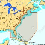
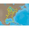
C-MAP NA-M023 Max Wide C Card Gulf Coast, Great Lakes and Rivers
The C-MAP NA-M023 Max Wide C Card Gulf Coast, Great Lakes and Rivers is a navigation chart card designed for those who want to explore the waters of the Gulf Coast, Great Lakes, and Rivers. This chart card provides comprehensive coverage of the region, including detailed charts, harbor charts, and marina charts. With its wide coverage area, the C-MAP NA-M023 Max Wide C Card Gulf Coast, Great Lakes and Rivers is perfect for cruisers, fishermen, and sailors who need accurate and reliable navigation data.
The C-MAP NA-M023 Max Wide C Card Gulf Coast, Great Lakes and Rivers offers a range of features, including detailed shoreline, buoys, beacons, and other navigation aids. The chart card also includes information on water depth, marine life, and other important details that can help you navigate the waters safely and efficiently. With its high-resolution charts, the C-MAP NA-M023 Max Wide C Card Gulf Coast, Great Lakes and Rivers provides a clear and accurate view of the marine environment, making it an essential tool for anyone who spends time on the water.
In addition to its comprehensive coverage and detailed charts, the C-MAP NA-M023 Max Wide C Card Gulf Coast, Great Lakes and Rivers is also easy to use. The chart card is compatible with a range of GPS plotters and chart plotters, and its intuitive interface makes it easy to navigate and find the information you need quickly and easily. Whether you’re a seasoned sailor or just starting out, the C-MAP NA-M023 Max Wide C Card Gulf Coast, Great Lakes and Rivers is an invaluable resource that can help you make the most of your time on the water.
Why pick the C-MAP NA-M023 Max Wide C Card Gulf Coast, Great Lakes and Rivers:
- Comprehensive coverage of the Gulf Coast, Great Lakes, and Rivers
- Detailed charts, harbor charts, and marina charts for accurate navigation
- High-resolution charts for a clear and accurate view of the marine environment
- Easy to use and compatible with a range of GPS plotters and chart plotters
Where to use it:
The C-MAP NA-M023 Max Wide C Card Gulf Coast, Great Lakes and Rivers is perfect for:
- Cruisers who want to explore the waters of the Gulf Coast, Great Lakes, and Rivers
- Fishermen who need accurate and reliable navigation data
- Sailors who want to make the most of their time on the water
- Anyone who wants to navigate the waters safely and efficiently
Tips for maintenance:
To get the most out of your C-MAP NA-M023 Max Wide C Card Gulf Coast, Great Lakes and Rivers, be sure to:
- Regularly update your chart card to ensure you have the latest navigation data
- Store your chart card in a cool, dry place to prevent damage
- Handle your chart card with care to prevent scratches or other damage
- Consult the user manual for troubleshooting and maintenance tips