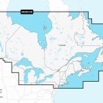
Garmin NVUS012R Navionics Vision+ Canada, East & Great Lakes microSD
Model: 010-C1484-00
- Integrated Garmin and Navionics® content, with an updated color palette and Navionics style appearance, provides exceptional coverage, clarity and detail
- Easy access to daily chart updates is available via the ActiveCaptain® app
- High-resolution relief shading feature combines color and shadow to give you an easy-to-interpret, clearer view of bottom structure than contour lines alone
- Built-in Auto Guidance+™ technology uses your desired depth and overhead clearance, along with chart data and frequently traveled routes, to calculate a suggested path to follow from dock to dock (Auto Guidance is for planning purposes only and does not replace safe navigation operations.)
- High-resolution satellite imagery overlaid with navigational charts gives you a realistic view of your surroundings — ideal for entering unfamiliar harbors or ports
- Aerial photography of ports, bridges, docks, navigational landmarks and more provides a better sense of your surroundings above the waterline
- Side scan images capture submerged features such as fallen timber, fish attractors, wrecks, potential hazards and more on select U.S. lakes
- Sonar imagery reveals bottom hardness clearly and in color, highlighting both subtle and dramatic transition areas on select U.S. lakes
- Unique 3D views, such as MarinerEye and FishEye, provide additional perspective both above and below the water line
- NOAA raster cartography is available as a free downloadable feature via the ActiveCaptain® app and can be displayed on your mobile device or compatible chartplotter
- Depth range shading lets you select up to 10 color-shaded options and view your target depths at a glance
- For improved fishing charts and navigation, up to 1’ contours provide a more detailed depiction of the bottom structure
- To aid in navigation, the shallow water shading feature highlights depths up to a user-defined level
- ActiveCaptain® community content provides valuable POIs, recommendations and advice from boaters with firsthand experience of the local environment
- Cartography updates are available via annual renewable subscription (the first year of updates is included)
Detailed coverage of coastal and inland waterways of Eastern Canada (except YT and NU). Coverage includes all the Great Lakes, the St Lawrence River, The Maritime Provinces and the Grand Banks.
Plot your paradise – with the best, most up-to-date Garmin Navionics Vision+™ premium marine cartography. For offshore or inland waters, this all-in-one solution offers premier-grade chart features, including detail-rich integrated mapping of coastal features, lakes, rivers and more. It features high-resolution relief shading, 3D views, satellite imagery, advanced Auto Guidance+™ technology and access to daily updates via the ActiveCaptain® app for the freshest chart data every time out. Combining the best features of Garmin and Navionics® automatic routing solutions, Auto Guidance+ gives you a suggested dock-to-dock path to follow through channels, inlets, marina entrances and more. (Auto Guidance is for planning purposes only and does not replace safe navigation operations.) Multiple shading options aid in shallow water navigation and make it easy to select depth ranges for the best fishing spots. Downloadable NOAA raster imagery is also available for those who want the familiar look of paper charts. (Availability of features may vary by region.)