Garmin VCA013R G3 Vision Labrador Coast Les Mechins-St. George’s Bay VCA004R – microSD™/SD™ card
Model: 010-C0698-00
- Industry-leading coverage, clarity and detail with updated coastal charts that feature integrated Garmin and Navionics® content
- Auto Guidance technology quickly calculates a suggested route by using your desired depth and overhead clearance
- Includes Depth Range Shading for up to 10 depth ranges, enabling you to view your target depth at a glance
- Up to 1’ contours provide a more accurate depiction of the bottom structure for improved fishing charts
- To give a clear picture of shallow waters to avoid, the Shallow Water Shading allows for shading at a user-defined depth
Experience unparalleled coverage and brilliant detail when you’re on the water. BlueChart g3 Vision coastal charts provide industry-leading coverage, clarity and detail with integrated Garmin and Navionics content.
Whether you are fishing or cruising, select a spot, and get a route showing you the general path and nearby obstructions at a safe depth1.
This feature displays high-resolution Depth Range Shading for up to 10 depth ranges so you can view your designated target depth.
To give a clear picture of shallow waters to avoid, this feature allows for shading at a user-defined depth.
BlueChart g3 Vision charts feature 1’ contours that provide a more accurate depiction of bottom structure for improved fishing charts and enhanced detail in swamps, canals and port plans.
High-resolution satellite imagery with navigational charts overlaid gives you a realistic view of your surroundings. It’s our most realistic charting display in a chartplotter — ideal for entering unfamiliar harbors or ports.
This underwater perspective shows 3-D representation of bottom and contours as seen from below the waterline. Interface with sonar data for a customized view.
This view provides a 3-D representation of the surrounding area both above and below the waterline.
Crystal-clear aerial photography shows exceptional detail of many ports, harbors and marinas and is ideal when entering unfamiliar ports.
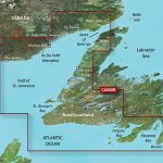
Coverage of the eastern and southern coasts of New Foundland from St. Barbe in the Strait of Belle Isle to Hermitage Bay, including Bonavista and St. John’s. Also covers the Labrador Coast from Forteau Bay to Nain Bay, including Lake Melville.
Specifications
| BlueChart g3 Vision |
| Integrated Garmin and Navionics content | Yes |
| Auto Guidance technology | Yes |
| Depth range shading | Yes |
| Up to 1′ contours | Yes |
| Shallow water shading | Yes |
| Raster cartography | Yes |
| High-resolution relief shading | Yes |
| Unique 3-D views | Yes |
| High-resolution relief imagery | Yes |
| Aerial photos | Yes |
| BlueChart g3 |
| Integrated Garmin and Navionics content | No |
| Auto Guidance technology | No |
| Depth range shading | No |
| Up to 1′ contours | No |
| Shallow water shading | No |
| Raster cartography | No |