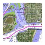
Garmin VUS515L Vision G3 Brownsville – Key Largo
Model: 010-C0744-00
- Provides industry-leading coverage, clarity and detail with updated coastal charts that feature integrated Garmin and Navionics® data
- Auto Guidance technology uses your desired depth and overhead clearance to calculate routes and show a suggested path to follow
- High-resolution relief shading combines color and shadow to give you an easy-to-interpret, clearer view of bottom structure than contour lines alone
- Depth Range Shading provides up to 10 depth ranges, enabling you to view your target depth at a glance
- Up to 1’ contours provide a more accurate depiction of the bottom structure for improved fishing charts and navigation in swamps, canals and marinas
Experience unparalleled coverage and brilliant detail on the water. BlueChart g3 Vision coastal charts provide industry-leading coverage, clarity and detail with integrated Garmin and Navionics data, Auto Guidance technology and high-resolution relief shading.
The Auto Guidance feature uses your desired depth and overhead clearance to calculate a route and a suggested path to follow.
High-resolution relief shading combines color and shadow to give you an easy-to-interpret, clearer view of bottom structure than contour lines alone.
The closer the contour lines, the more accurate the depiction of the bottom structure for improved fishing charts and navigation in swamps, canals and marinas.
If you prefer your display to have the look of paper charts, NOAA raster cartography2 is available as a free downloadable feature via the ActiveCaptain® app.
This feature provides up to 10 depth ranges, enabling you to view your target depth at a glance.
This feature allows you to use shading to designate the shallow water depths you need to avoid.
These detailed images of ports, marinas, bridges and navigational landmarks help provide you with superior situational awareness.
MarinerEye and FishEye views provide additional perspective both above and below the water line.
Note: The areas outlined in color depict the approximate coverage areas of the relief shading data included in the Vision card.
Detailed coverage of the Gulf of Mexico from Brownsville, TX to Plantation Key, FL including Corpus Christi, TX, Matagorda Bay, Galveston Bay, Port Arthur, TX, Atchafalaya Bay, the Mississippi Delta, Chandeleur Islands, Tampa Bay and the Florida Keys west of Key Largo. Also includes Lake Ponchartrain and Lake Maurepas to Vermilion Bay and Lake Calcasieu. Bathymetric coverage of offshore features from Northwest Slope to Tortugas Terrace including Keathley Canyon, Green Canyon, Orca Basin, Mississippi Canyon, Southwest Pass, DeSoto Canyon, Florida Middle Ground, Howell Hook, and Tortugas Bank.
Specifications
| BlueChart g3 Vision |
| Integrated Garmin and Navionics content | Yes |
| Auto Guidance technology | Yes |
| Depth range shading | Yes |
| Up to 1′ contours | Yes |
| Shallow water shading | Yes |
| Raster cartography | Yes |
| High-resolution relief shading | Yes |
| Unique 3-D views | Yes |
| High-resolution relief imagery | Yes |
| Aerial photos | Yes |
| BlueChart g3 |
| Integrated Garmin and Navionics content | Yes |
| Auto Guidance technology | Yes |
| Depth range shading | Yes |
| Up to 1′ contours | Yes |
| Shallow water shading | Yes |
| Raster cartography | Yes |